
Up the Skeena by Sternwheeler
Re-published from Skeena-River of Destiny by R. Geddes Large

This account of a trip up the Skeena River on a sternwheeler is from an article by an anonymous writer, published in the Skeena District News of 1904:
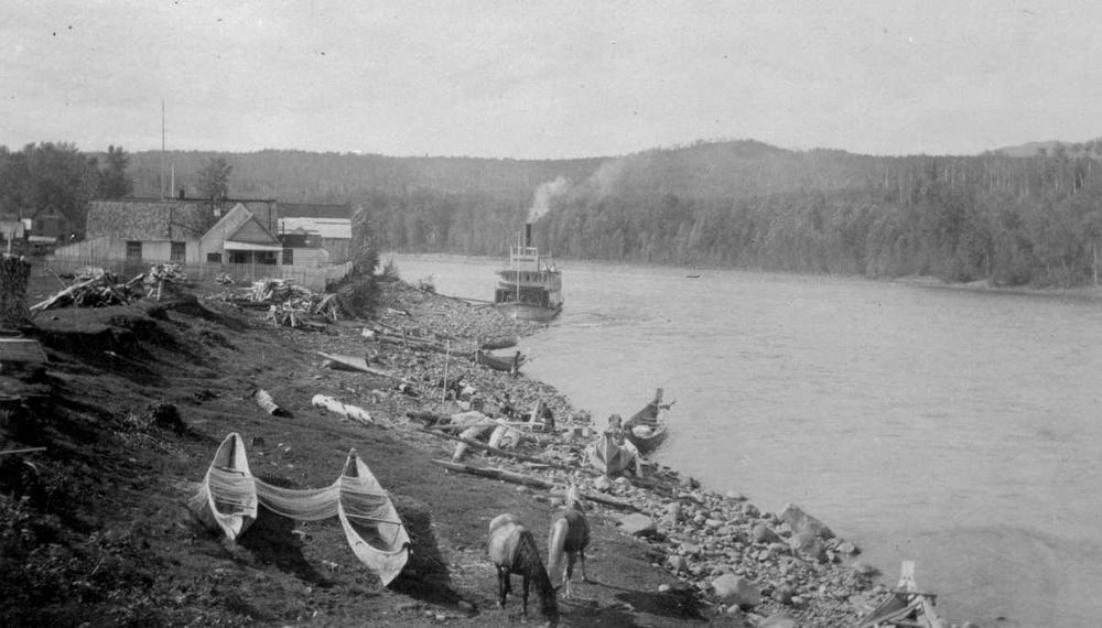
“Our steamer, the Hazelton, is moored to Frizzell’s wharf at Port Essington, loading the last of her freight; and with her passengers already aboard. These are mostly on the upper deck, but there is a group of Indians with their bundles camped on the forward deck, quick to learn the advantages of the white man’s mode of travel. A blast on the whistle, the lines are cast off and we nose out into the current of a favorable rising tide.
“We quickly cross the mouth of the Ecstall River and Port Essington fades in the distance. About six miles up on the right bank we notice a cluster of small buildings, from one of which steam is rising. This is the famous Hot Springs frequented by fishermen and others to cure almost every ailment. The volume of water is small but it is very hot as it issues from two or three separate clefts in the rock.
“On the other bank, we are soon abreast of the Kyex (Khyex) river and the site picked by certain optimistic gentlemen as the terminus for the proposed railway. Kyex City (Khyex) has been staked by McIntosh, Lorenz and partners, but so far it is nothing but bush and doesn’t hold our interest long. Rounding Telegraph Point, the location of one of the cabins on the Dominion Government Telegraph line to Port Simpson, we are soon at the limit of tidewater and the river narrows down. Numerous islands covered with cotton-wood, and bars piled high with old snags choke the river and Captain Bonser has to know what he’s doing to find his way along the tortuous channel.
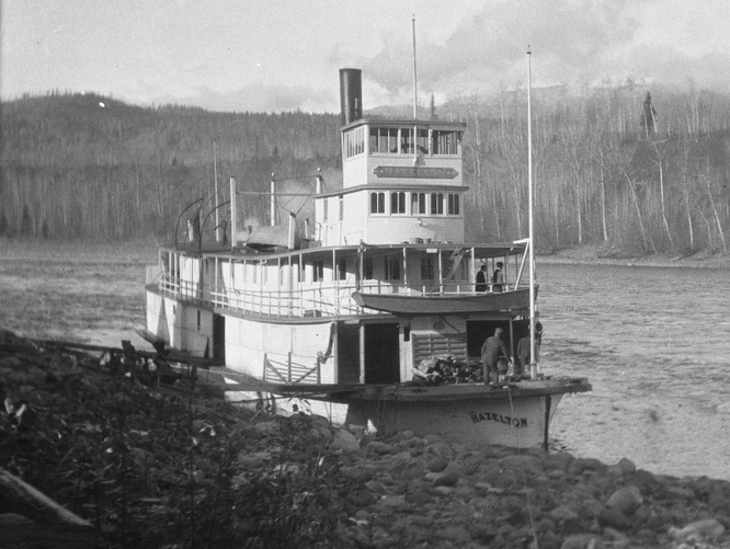
Courtesy Wrathall Photos, Prince Rupert City and Regional Archives
“Snow-clad mountains tower above us on either side, broken occasionally by the entrance of mountain tributaries, with the Kasiks and Exchamsiks on the left and then the Gitnadoix on the right. Gitnadoix valley, with its lofty snow-capped mountains on both sides, spreads itself out to the south of the Skeena towards the head of Kitamat Arm and the headwaters of the Big Falls on the Ecstall River. Although a very swift stream for a distance of five miles up from its mouth, the Gitnadoix River runs comparatively sluggishly from there on for a distance of eight miles to a lake some three miles long. A large stream joins it a few miles below the lake where many years ago an Indian village used to be, but a spot now ornamented only by the picturesque hunting lodge of Charlie Jones. This stream runs east to the divide between it and the Wedeene River, which empties a broad body of water into the Kitamat River. Several quartz claims have been recorded on the Wedeene, and considerable work has been done upon them, showing excellent prospects in copper-gold ore.
“Gitnadoix Lake is hemmed in on the north and west by high and steep mountains. There must be extensive deposits of iron in the mountains at the foot of the lake, as all the streams are stained red with iron oxide. At one place there are barrels of pure oxide which has been deposited by a little rivulet oozing out from a crevice in the rock, and the Indians in years gone by used to get their supplies of red paint from that particular spot. The area is a hunter’s paradise with bear and mountain goat plentiful and good fishing in the lake and streams.
“Speaking of mountain goat, as we pace the deck of our steamer we can see them from time to time, high up on the rocky cliffs, standing still in remote isolation or picking their way along the precipitous mountainside. As the evening approaches we arrive at Graveyard Point and there tie up for the night, having travelled fifty miles from Port Essington. This is the site of another Telegraph station and we find it under the care of Slim Dobbie and J. D. Wells. We are called to a satisfying dinner in the dining saloon, and after watching the crew for a time as they take on a fresh supply of cord-wood, we retire to our cabin and a comfortable night’s sleep on a spring bed. What a far cry from the canoe and the rocky shore!
“Captain Bonser has us under way again early the next morning and as we come abreast of the Lakelse River, regales us with stories of his fishing experiences on that wonderful trout stream. Indeed it was often called Trout River and the Captain claims to have caught twenty-five to fifty trout there on many an occasion in an hour’s fishing. The remains of an old Indian village can be seen near the mouth, and the land is still an Indian reservation. It was used originally by some of the Port Simpson Indians. The Captain also tells us of the wonderful Hot Springs close to the lake at the head of the river. Steam can be seen rising for a hundred feet into the air, and the spring forms a pool of unknown depth with water close to the boiling point. It has a very considerable flow and some day will undoubtedly be of commercial value.
“Just above the Lakelse River we pass another river on the opposite bank, flowing in from the north, and this is the Kitsumgalum. At its mouth is another Indian village, still occupied, but by only a few Indians. Most of the tribe have moved down to Port Essington to live on the special reserve given them by Robert Cunningham. This river too drains a lake, and there are reports of gold up the valley. Two prospectors, Harvey Snow and Captain Madden, have been working some claims up there on a creek near the headwaters of Lorne Creek. Our interest in the Kitsumgalum is speedily diverted, however, by the ugly-looking riffles our boat is now navigating; but the Captain knows what he is doing and we pass over them successfully and approach the Little Canyon, where we tie up at Thornhill’s Landing.
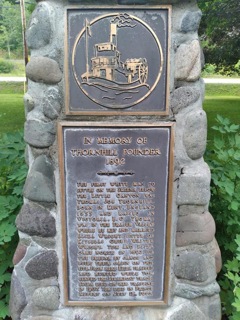
Photo by Charles LeRoss

“Thomas Thornhill is one of the early pioneers and he has a patch of one hundred and sixty acres, with about four acres already in cultivation. He is proud of his flower garden, and when we go in for lunch some of his flowers bedeck the dining table.

Photo by Charles LeRoss
“The Skeena at the Little Canyon is only about one hundred yards wide, with mountains on the north side and a low point of rock on the south shore. During the freshets it is a nasty piece of water, but navigation has improved since the Dominion Government blasted out a large rock in the center of the channel. About a mile further on, we pass Bill Bostet’s ranch, only recently pre-empted, and then on the north bank we see Dave Stuart’s place, where we tie up to his landing. Dave is another old-timer and his ground is producing wonderfully with cherry, apple and plum trees and a good assortment of vegetables. A look over this small farm, and an inspection of its products, convinces us that great agricultural possibilities lie dormant in the valley of the Skeena, awaiting only the advent of the railroad to render them available.
Photo by Charles LeRoss
“Right across the river from us we can see the outlet of the Zymoetz, or Copper River. It is one of the Skeena’s largest tributaries, a wild mountain stream that is impossible of navigation. It takes its rise far in the interior to the south, and at times of freshet its muddy waters can be traced right to the mouth of the Skeena. It is called Copper River because of the large amount of copper-stained float that has been found in its channel. M. C. Kendall was the first quartz prospector on this stream and in 1896, in company with Henry Frank, he located a promising quartz lead. It did not pan out and he extended his prospecting a little further up the Skeena where he located the I.X.L. and Emma groups of claims near the Kitselas Canyon. As we approach the Canyon, we are right in the heart of the most promising mineral area so far discovered on the Skeena. There are numerous other prospects besides those mentioned and the coming of the railroad and cheap transportation is all that holds up their development.
“Just before we reach the Canyon we pass the Kitselas Indian village, where there is a Methodist Mission, and at the foot of the canyon we tie up at the Telegraph Station where Mr. Daoust is in charge. There is also a Hudson’s Bay Company warehouse here and a road has been built to the upper end of the canyon. The Canyon, eighty miles from the coast, is about half a mile long and one hundred and fifty feet wide, with high cliffs on both sides, between which the Skeena, at high water, forces itself with a roaring noise and great velocity. Today it is comparatively peaceful and we pass through with little trouble, though to the novice it appears awe-inspiring and a little frightening.
“We are now encountering some very sharp riffles, but the river seems to be remarkably clear of rocks. The mountains on both sides gradually draw away from the river, and one begins to feel that he is getting away from the coast and the coast climate. We have passed the divide of the Cascades and are getting into the Interior country. High benches take the place of low land. Some, but by no means all, of this is agricultural land. Birch, maple, pine and aspen groves are now becoming common, and as we approach Lorne Creek, thirty-five miles above the Canyon, we know that we are beyond the moist atmosphere of the other side of the mountain range behind us.
“Lorne Creek empties into the Skeena on the north side and is not a large stream. It is the only creek flowing into the Skeena on which very rich placer claims have been located. During the later 80’s, about two million dollars in gold was taken from about a mile of ground on the creek by hundreds of men who flocked in after the first discovery was reported. The Creek is now considered worked out, but several hydraulic properties are being got into shape to be worked on a large scale. The Dryhill property is attracting the chief attention at present. The Dryhill is a very large deposit of auriferous gravel about a mile long and hundreds of feet high, situated about a mile from the mouth of the creek. It has been worked on a small scale for many years by Messrs. Raynard, McArthur and others, and with good success. It is now proposed to construct a flume from higher up on Lorne Creek and run the water over the Dryhill. Twenty men are presently at work there and an up-to-date dredging plant is also to be installed on Lorne Creek this summer.
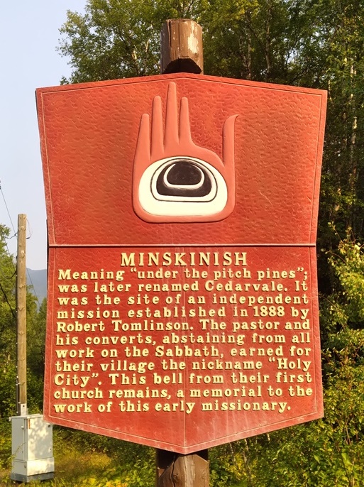
“For the next twenty-five miles the scenery continues unchanged and we finally, come up to the Indian village of Minskinish, a mission established by the Rev. Robert Tomlinson. Across the river is a sawmill and telegraph station. This is a clean-looking, up-to-date Indian village, with about two hundred people. After dropping the mail and a little freight, we push on to Kitwanga, a larger Indian village on the north side of the river, close to the mouth of the Kitwancool River. This village is strung along the river bank for some distance and the houses are fronted with a number of fine totem poles. This is an Anglican Mission and also a Hudson’s Bay Company post. There is supposed to be placer gold on the Kitwancool but the Indians will not allow anyone to mine it.
“Andimaul, a little further up, calls for a short stop, and then we cross the river to Kitseguecla on the south bank. This is one of the old Indian villages and the site of another Methodist Mission. it is located at the mouth of the Kitseguecla river which also is reported to have gold in small quantity, and further up the valley there are reports of coal deposits.
Courtesy the BC Provincial Archives
“We have had some exciting moments on the passage thus far, particularly at points with such picturesque names as Hardscrabble Rapids, Devil’s Elbow, Sheep’s Rapids, Whirly-gig and Klootchman’s Canyon, but the captain assures us that the hardest part of the river is yet to come. After leaving Kitseguecla we find the river very rocky and a string of boulders right across the river is called the Beaver Dam. It requires careful navigating to squeeze between two of these submerged rocks, apparently the only opening which would permit the passage of a boat this size.
No sooner is that behind us than the whole river seems to be full of boulders and the Hornet’s Nest is a very descriptive name. However, all things come to an end and eventually we push our way up stream until the mouth of the Bulkley River appears, and, crossing it, we tie up to the landing in front of the village of Hazelton.”◀
